Category: Bike trails
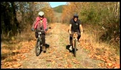 Those of you trapped inside your homes by the winter storm back East might enjoy watching this video about the picturesque Moonville Rail Trail that meanders for 10 miles through the scenic hills of southeastern Ohio.
Aside from the pleasant scenery and the sounds of twittering birds and mountain bike wheels crunching over gravel, there's a good lesson here.
Those earnest volunteers who are trying to create trails out of abandoned railway rights-of-way might be interested to know that the Moonville Rail-Trail Association avoided using county money to build the trail that connects the small towns of Zaleski and Mineral.
Founder Neil Shaw says the whole effort was accomplished with volunteers, donations and grant money ….
Continue reading
Permanent link to this article: https://www.bikingbis.com/2009/12/21/thinking-outside-the-box-to-create-ohio-bike-trail/
 When two girls, aged 11 and 10, on bicycles were struck and killed by a van driver in October 1987, the people of Davie resolved to make the small south Florida city safer for bicyclists.
By the end of the year the town council budgeted $150,000 for its first bike trail. Within six months work began on a 3-mile bike trail adjacent to the street where the girls were killed.
Twenty-two years later, Davie boasts a network of 135 miles of bike paths and horse trails that connect the two dozen parks in the town with a population of 90,000.
When you consider the reputation of Florida among bicyclists, the feat of building so many bike trails in the town is remarkable. ….
Continue reading
Permanent link to this article: https://www.bikingbis.com/2009/11/20/florida-town-reacts-to-bicycle-tragedy-by-building-bike-trails/
 We can vote early and often for our favorite bike trails in this election.
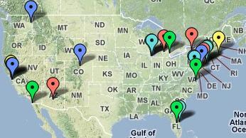
A few weeks ago Google Maps sought nominations for off-road photographic visits by its Street Views trike.
After receiving 25,000 ideas, the Google Maps staff came up with 24 finalists (trails in blue on map). They're asking us to vote for our favorites; multiple times if we feel like it.
Five bike trails have been nominated for a visit by the Google Maps Street Views trike. They are the Centennial Trail in Washington, Capital Crescent Trail in the DC area, Schuylkill River Trail in Pennsylvania, Boulder Creek Trail in Colorado, and the Stevens Creek Trail in California…
Continue reading
Permanent link to this article: https://www.bikingbis.com/2009/11/13/five-bike-trails-nominated-for-street-views-on-google-maps/
 Bicyclists in Seattle should feel fortunate that the creators of Ride the City chose their town as the latest addition to the online bike-route mapping tool.
Since launching the website for New York City last year, Vaidila Kungys and Jordan Anderson have added Chicago, Austin, Louisville, San Diego and now Seattle to their mapping tool.
Don't blame these guys for the slow roll-out; Vaidila told me that they have full-time jobs and update the website during coffee breaks, lunches and after work.
Essentially, Ride the City is a mapping tool that finds the most direct route between two points, much like Google maps does for car travel [you can give it a test drive on the jump] ….
Continue reading
Permanent link to this article: https://www.bikingbis.com/2009/10/28/ride-the-city-directs-bike-riders-to-safest-routes/
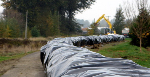
Any plans you had for bicycling the Green River Trail in the next few years are being sandbagged.
Crews are racing to erect a 3- to 4-foot high sandbag wall along the trail to help contain expected floodwaters in Kent and Tukwila if heavy rains strike the area this winter.
The work stems from problems at the Corps of Engineer's Howard Hanson Dam upstream, where engineers are concerned about the structural integrity of the dam. They'll be releasing more water to reduce pressure on the dam, which could mean flooding downstream in the Green River Valley.
The Green River Trail could be closed to bicycles for up to five years, if it takes the Corps that long to figure out how to solve and repair the problem. With the sandbags in the middle of the trail that sits on top of the levee, there's not enough room for safe usage by bike riders and pedestrians.
The less scenic, but more direct, north-south Interurban Trail is slated to remain open. …..
Continue reading
Permanent link to this article: https://www.bikingbis.com/2009/10/21/green-river-trail-will-be-closed-to-bikes-for-3-to-5-years/
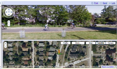
 Google Maps is looking for help in selecting places to send its StreetView trike.
Noting that some of the most interesting and scenic locales are not accessible by car, Google is accepting suggestions on what else should be featured on StreetView.
Of course, I'm thinking of nominating the most-used or most picturesque bike trails in the Pacific Northwest.
The Olympic Discovery Trail on the Olympic Peninsula comes to mind first, as it winds along between the Strait de Juan de Fuca on the north and the snowy peaks of the Olympic Mountains on the south. That's a picture of the trail east of Port Angeles where it skirts the seawall ….
Continue reading
Permanent link to this article: https://www.bikingbis.com/2009/10/16/tell-google-about-your-favorite-bike-trail-for-streetview/
Google keeps adding data to its maps to make them more detailed.
That's good news for bicyclists who want to find bike trail routes in their cities that might take them near their destinations.
As I found from tracing some bike trails in the Seattle area, some are labeled and some aren't. Some are mislabeled. Some vanish from sight in places then reappear later. But it's a start, and the information on the Google maps is only as good as the sources.
At its Google Lat Long blog, the company tells about some of the improvements and says “…cyclists will now find many more trails and paths to explore. Soon we even plan on providing you with biking directions to take advantage of this new data …
Continue reading
Permanent link to this article: https://www.bikingbis.com/2009/10/13/google-maps-adding-bike-trails-directions-are-next/
 Not-in-my-backyard naysayers often allege that proposed bicycle trails will ruin the quality of life in their neighborhoods and destroy property values.
But it seems that the opposite is the case in follow-up studies or polls of neighbors.
For instance, the Ithaca (NY) Journal reports that 81% of residents who live next to that city's three main trails say the bike and hike trails improved or greatly improved their neighborhoods. Only 7% of the survey's respondents believe the trails made their neighborhoods worse.
In fact, many neighbors found the trails such an improvement that they use them regularly ….
Continue reading
Permanent link to this article: https://www.bikingbis.com/2009/10/08/poll-says-bike-and-hike-trails-improve-neighborhoods/
 The Walkway Over the Hudson State Historic Park opened this past weekend in Poughkeepsie, New York, drawing thousands of people on bikes and on foot to enjoy the new views of the Hudson River.
The 6,767-foot-long bridge is being touted as the world's longest pedestrian and bike-only bridge. It even surpasses the length of the 4,226-foot Big Dam Bridge over the Arkansas River in Little Rock.
The old railroad bridge will connect to 27 miles of rail trails and riverfront parks already built or planned for construction on either side of the river in Ulster and Duchess counties ….
Permanent link to this article: https://www.bikingbis.com/2009/10/05/new-bike-crossing-over-hudson-river-is-worlds-longest/
 Those of you heading to Wenatchee, Washington, for Saturday's Dam2Dam charity bike ride should consider paying a visit to the Apple Capital Recreation Loop Trail if you have any extra time.
I explored the trail earlier this month on an overnight camping stay in the Wenatchee area during my bicycle tour from Cle Elum, over Blewett Pass and up the Columbia River. The trail passes through natural wetland settings and urban parkland and offers spectacular mountain views from both sides of the river.
The paved loop is a wonderful 10-mile trail that hugs both shorelines of the Columbia River with bike-only crossings at the north and south end. It's heavily used by commuters and recreational cyclists, and it's also an excellent way for visitors to get a feel for the Columbia River environment. ….
Permanent link to this article: https://www.bikingbis.com/2009/09/25/biking-the-wild-and-tame-sides-of-the-wenatchee-loop-trail/

Recent Comments