There’s something about historical highway plaques and markers that are extremely distracting when I’m bicycling through new territory.
When we started our cross-country bike ride in Virginia, for instance, my poor friend Bruce probably thought we’d never get to Kentucky as I was constantly stopping to read the signs.
There were lots of Civil War and Revolutionary War battles to commemorate in the commonwealth of Virginia, and it seemed half of them were on the Trans-America bike route. At present, Virginia has 2,200 such signs.
Now I’ve learned about two popular bicycle trails (I’m sure there are more) that are in the process of erecting signs that give traveling bicyclists a deeper understanding of the area through which they’re passing.
Three Rivers Heritage Trail
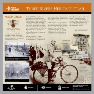
One of them is the Three Rivers Heritage Trail in Pittsburgh, which is erecting signs that portray the city’s rich history and landscape. One of the signs, above, depicts Pittsburgh’s early bicycle explorer Frank Lenz, whose story is retold in David Herlihy”s book The Lost Cyclist: The Epic Tale of an American Adventurer and His Mysterious Disappearance.
The trail, supported by Friends of the Riverfront, is the last leg of the Great Allegheny Passage (GAP) from Cumberland, MD to Riverfront Park at the confluence of the Allegheny and Monongahela rivers in Pittsburgh. The “missing link” on the outskirts of Pittsburgh should be completed in June so more bicyclists are expected to flood into the city past signs like these.
Centennial Trail
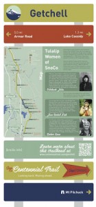
The Centennial Trail Coalition in Snohomish County, just north of Seattle, is involved in plans to erect historical signs at seven trailheads on the 30-mile-long rail-trail.
The signs announce the trailhead name, distances to the next trailhead, a locater map for the trail, braille and a QR code, and some content. In the case of the Getchell trail head, it depicts Native American women.
Called the “Past Forward” project, it is being funded by the Snohomish County economic development program. It seeks to tell the history of the areas surrounding the trails as well “explore the dynamic future” of the region. In addition to the signs, the project will comprise a website, mobile phone app, collector cards, vidoes, and public art.
Those with history to share can contact the project at info@centennialtrail.com.
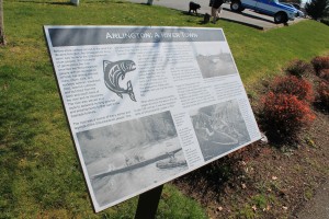
Meanwhile, Arlington has had historical signs in place along the Centennial Trail for several years. The signs, placed next to the trail, display historical photos and information about Arlington’s place in the aviation, logging and railroad industries.
Other historical and interpretive signs on area rail-trails come to mind — such as those on the John Wayne Pioneer Trail in Iron Horse State Park.
The signs are a great addition to bike trails. They help to enrich traveling experience for bicyclists and can encourage them to explore the area some more.


2 comments
My riding partners have learned that I stop for every new historical marker on rides. I read them and then take a picture of them which helps in remembering the trip. It is so much easier to do at 17 mph than 65mph.
Author
That’s what I do too, especially if I’m going to write a piece about the ride. Taking a picture of a historical marker is a whole lot easier than taking notes!