
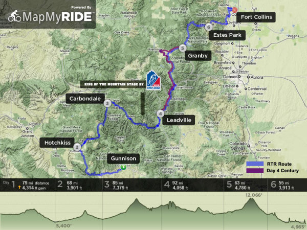
Bicycling enthusiasts on the 27th annual Ride the Rockies bicycle tour will cross five mountain passes on their way from Gunnison to Fort Collins in 2012.
The organizers of the popular event presented by the Denver Post announced this weekend the 442-mile route and seven host cities for the event that draws 2,000 riders in a lottery that leaves others waiting in the wings.
Registration for this year's June 9-15 bicycle tour runs today (Sunday) through Feb. 24. Two thousand bicyclists will be chosen at random in the lottery; selections are announced March 2.
This year's host cities and passes are:
June 10: Gunnison to Hotchkiss — 79 miles, north rim of Gunnison National Park (3,077 ft. elevation gain);
June 11: Hotchkiss to Carbondale — 68 miles, McClure Pass – 8,755 feet (3,901 ft. elevation gain);
June 12: Carbondale to Leadville — 85 miles, Independence Pass – 12,095 feet (7,379 ft. elevation gain);
June 13: Leadville to Granby — 92 miles, Fremont Pass – 11,319 feet and Ute Pass – 9,165 feet (4,058 ft. elevation gain);
(June 13 century option is 106 miles via Williams Fork, 4,147 ft. elevation gain)
June 14: Granby to Estes Park — 63 miles, Trail Ridge Road, Rocky Mountain National Park and Milner Pass – 10,758 feet (4,780 ft. elevation gain);
June 15: Estes Park to Fort Collins — 55 miles, Glen Haven, Masonville and Horsetooth Reservoirs (1,742 ft. elevation gain).
Highlights
Some of the highlights include the Gunnison and Rocky Mountain National Parks, where bicyclists will rideTrail Ridge Road. It's the highest continuous motorway in the US with 8 miles above 11,000-foot elevation.
This year's bike tour also includes a Day 3 King of the Mountains stage
— a tie in with the USA Pro Cycling Challenge bike race scheduled in
August.
Bicyclists interested in extending their Rocky Mountain high can register for the 2012 Bicycle Tour of Colorado, which leaves Fort Collins on June 17 for Laramie and Saratoga, Wyoming, followed by a return to Colorado and host cities Crain, Steamboat Springs and Walden.
Early disclosure
The route for each year's Ride the Rockies is a closely guarded secret until the official announcement. Organizers this year had to disclose that they were heading to, or through, Fort Collins this year when they needed public approval to use the roads in that area.
The home county of Fort Collins limits specific county roads to two bike events a month, and Ride the Rockies would have been the third. With each host town earning an estimated $250,000 during the ride, apparently public officials thought it would be worth allowing a third ride.
Elevate
While Ride the Rockies bicycle tour is considered exceptionally mountainous and something like RAGBRAI (Register's Annual Great Bicycle Ride Across Iowa) might be considered flat, I discovered last year that the Iowa bike tour has more elevation gain than the Colorado ride on some years.
That isn't the case in 2012, where Ride the Rockies' 24,937-foot elevation gain surpassed Iowa's mountainless 16,125 feet.
But the hardest day on RAGBRAI — Marshalltown to Cedar Rapids — at 3,576 feet has more elevation gain than the first and last days of Ride the Rockies.
With five mountain passes, this year's riders need a couple of easy days.
Recent Comments