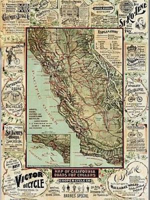
 This vintage Map of California Roads for Cyclers certainly brings back pleasant memories of bike rides I used to take around the Golden State.
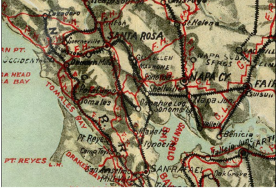
The 1896 map is reproduced at the Big Map Blog in minute detail so viewers can zoom in on detailed routes. [See the San Francisco Bay Area below.]
We used to live in the Central Valley, and I see all the way stations from my bike rides during that period — Modesto, Copperopolis, Chinese Camp, Big Oak Flat, and Angels Camp, among them.
It's interesting to see that those were all bicycling destinations 100 years before I took to the road there.
Over in the Bay Area, I see routes that connect Pleasanton, Livermore, Sunol, Niles (I assume a railroad stop in Niles Canyon) and a place called Ellis that I don't recall.
 As interesting as the map are the advertisements that surround it. Victor Bicycles really stands out, as does Si-Ko-Lene, a chain lubricant. As bicycling is still kind of a new thing, a couple of bicycling schools also paid for space on the map.
The owner of the Big Map Blog says he stumbled across the the treasure trove of maps while doing research on a film.
“I found thousands of old, beautiful maps that are sadly being kept from
the public that deserves them — sometimes by clumsy or unwieldy
government ftp sites, and other times by archives with steep fees for
research, and steeper fees for reproduction. I felt strongly that
something should be done about this.”
Two-thirds of the maps are from four sources: 1.) the Perry-Castañeda Map Collection, 2.) the Rumsey Map Collection, 3.) the Library of Congress, and 4.) the fantastic new USGS Earth Explorer.
He's posting the maps on his website. You can leave your email and hometown on the website for a notification when your city comes up.
I appreciate the works that goes into this, and I'm glad the webmaster is making these public.

Recent Comments