
 Some bicyclists will do anything to avoid a climb. They route their rides through the flat lands and never taste the challenge of vertical exertion.
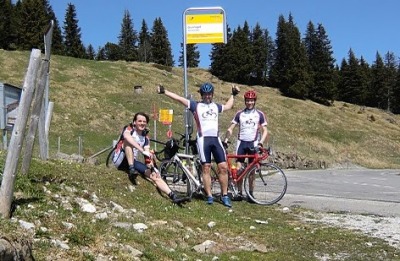
At the other extreme is Dennis Wegewijs, a Dutch bicycling enthusiast who searches out the most difficult climbs — namely Alpine passes — to summit on his bicycle with his friends.
Dennis said that at some point, they decided to ride their bicycles over all the passes of the Alps. [That's Dennis, flanked by Daniel and Michel, on Gurnigel Pass near Bern last year.] Why?
“By that time, we hope that we have cycled all the +/- 480 paved passes of the Alps.”
So far, they've pedaled up about 45 passes. They have quite a few to go.
CyclingtheAlps.com
That enthusiasm for Alpine cycling prompted Dennis to research everything he could find on the passes before taking off on his trips. One day he had the idea to bundle all the information available on the Internet for each pass and he launched a website called CyclingtheAlps.com.
This is an amazing website for anyone wanting to explore the Alps. At first, Dennis offered maps, profiles and information on the passes.
Now, with the help of an app he spent the past year developing, he offers up to a dozen different ways to experience each pass without ever climbing on a bicycle. Google Earth is required for some applications.
In addition to the route and profile, there are Streetview tours from both sides, Explore (like a first-person shooter), a cycling game, cycling video, full screen slideshows, external links to Cycling Challenge, Climbbybike and Qualdich and 3D tours (not available on all passes yet).
The Google Earth blog raved about the website earlier this year. The app is available for download at the Chrome webstore.
Giro d'Italia
I was of course oblivious to all of this until the day before the start of the Giro d'Italia when Dennis contacted me with a list of all the mountain climbs of this year's race. He said I could embed the profiles and, if available, the Streetview versions of each climb on my Giro d'Italia page.
This year's Giro will be won or lost on the mountains, with numerous climbs in the Alps and Dolomites, as well as Mount Etna. I agreed to the offer.
So, the plan is to run a preview of each climb the day before the stage. It will include a map of the route over the pass and the mountain route profile. If there's a “Streetview” available, I'll embed that too so armchair cyclists can enjoy a virtual bike ride over the top.
As an example, below is a “Streetview” version of a short climb near the end of Stage 3, Monday. (Look for the bicyclist you'll pass.) Hit the play button and sit back. [It works better on Chrome, Foxfire or Safari browsers.]
Lastly, I just want to publicly thank Dennis for the work he put into this worthwhile project. As a dad with a full-time job, it must have been difficult to find the time.
Recent Comments