

Another missing link in an off-road bicycling route between Seattle and the Cascades has been closed.
The state transportation and parks departments completed a 1.2-mile connector trail between the Issaquah-High Point Trail and the Preston-Snoqualmie Trail in December.
The trail, which cost $4.7 million, eliminates one of the gaps in the Mountains to Sound Greenway that runs from the Seattle waterfront to Central Washington generally along the Interstate 90 corridor.
The trail
I rolled up there last month to check it out. It starts across the street from the Issaquah-High Point Trail and is in much better condition.
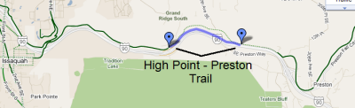
For anyone biking between Issaquah and Preston, the trail omits the need to use a winding section of road with no shoulder. The off-road trail ends short of Preston, but uses the wide shoulder of SE High Point Way before crossing the street to the Preston-Snoqualmie Trail.
The trail is made of crushed gravel and is well-graded. I rode it on 2-1/2 inch knobby tires, but it's suitable for thinner tires.
It's noisy with motor traffic, however, as it runs very close to I-90 on the south side. I'd recommend concentrating on the scenery to the north, which includes the woods along the rushing East Fork of Issaquah Creek where I spotted a kingfisher flitting from branch to branch.
There are a couple of bridges and a series of retaining walls, which might have contributed to the overall cost. The state parks department paid $3.5 million and the Department of Transportation put in $1.1 million to complete the funding.
There's a lot of recent planting along the trailside to screen the view of I-90 in the future; I've read that 200 fir and cedar trees and more than 5,000 shrubs are being planted.
History
The trail generally follows the old right-of-way of the Pacific Northern Railroad. The actual railroad right-of-way is now the streambed of the East Fork of Issaquah Creek, which was moved from its previous location by the construction of I-90.
In fact the bridge shown in the photo at top uses the old trestle from the railroad. Hard to believe, but it was nearly hidden by overgrown vegetation when work began on the path in the summer of 2010.
Filling the gaps
The Mountains to Sound Greenway nonprofit published a map (.pdf) of the gaps in the trail from the Seattle waterfront to Central Washington. It's hard to believe, but the greenway is less than 10 miles from completion.
Among those listed:
— .5 mile gap from waterfront to Beacon Hill trail in Seattle;
— 1.5 miles from east end of I-90 trail in Factoria to Bellvue city limits;
— 1 mile from I-90 trail at West Lake Sammamish to East Lake Sammamish Parkway;
— 2 miles from east end of Preston-Snoqualmie Trail on Lake Alice Plateau to Snoqualmie Valley Trail;
— 1 miles from east end of Coal Mines Trail in Cle Elum to the cross-state John Wayne Pioneer Trail.
The trail gaps in the Mountains to Sound Greenway are described in depth at the website.
Not listed are the five tunnel closures along the John Wayne Pioneer Trail (including the 2-mile-long Snoqualmie Tunnel) that are supposed to be temporary.
Recent Comments