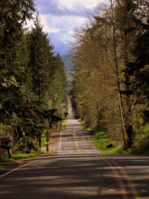
I have a bad habit of riding the same old routes on my bicycle, so I'm always trying to keep things fresh by looking for new roads. Scenic is good; points of interest or historic landmarks are a bonus.
That's why I was happy to stumble across the recently published Historic and Scenic Corridors Project of King County. Although not a bicycling map book, it contains a treasure trove of new roads to explore by bicycle.
The first ride I set out on did not disappoint. The Issaquah-Fall City Road described in the booklet, also published online, put me on a 5-mile route that has changed little from the early days of settlement when it was used as a wagon road by farmers before the arrival of the railroad to the region.
Wagon road
Originally seen as only a trace on early maps, it was officially established in 1883 as D.H. Thomas Road No. 99. It was part of a longer route that connected Renton to the Snoqualmie Valley through the town of Squak (later to become Issaquah). It climbed, then ran across a ridge that separates Issaquah and Fall City.
 Since much of that road between Renton and Snoqualmie Valley has undergone big changes over the years, it can no longer be considered historic, nor scenic.
This one 4.8-mile section that has been spared the suburbanization that other parts suffered, however. The stretch of “heritage corridor” stretches between SE Duthie Hill Road and 328th Avenue SE in Fall City. Check the King County corridor map and streetview at Google.
The narrow road twists and turns through forestland that hugs the road. That roadside vegetation is only interrupted by the occasional 19th or early 20th century farm or expansive views of the Snoqualmie Valley and the Cascade mountain range beyond.
Caution
Just a few words of caution: The Historic and Scenic Corridors Project is not a bike route manual. Some of the things that make these roads historic and scenic — no shoulders, sudden turns, poor line-of-sight, roller-coaster terrain — can also makes them dangerous for bicyclists.
So far, I've only bicycled the Issaquah-Fall City Road corridor, and that had very light traffic. Except for a couple of roads on Vashon Island, the remaining heritage corridors are in eastern King County. I plan to eventually ride them all.
Back road
The corridor description says this was the first wagon road to connect the earliest locations of Euro-American settlement in eastern King County — the Squak and Snoqualmie valleys. It became the secondary route between the two areas after the arrival of the railroad in the 1880s.
The route was extended as the automobile era began, but still remained in rough shape. Other routes carried the bulk of the traffic and it fell into the “backroads” category.
Bike loop
It's easy to create a 20-mile bike loop incorporating the Issaquah-Fall City Road by comparing the Historic and Scenic Corridor map to the King County Bicycle Map.
Starting at the Issaquah railroad depot, a bicyclist could take the Sunset Avenue route up to the Issaquah-Preston Trail at the Interstate 90 interchange. From there, look for the sign to Highlands and follow that route on the bike lane and sidewalks all the way over to the “newer” Issaquah-Fall City Road. There's some more climbing here, but look for the right turn onto Issaquah-Fall City Road (the main route continues as Duthie Hill Road).
This is the historic corridor. It passes the Grand Ridge Park, a swamp and some farms. A long red barn standing to your right is featured in a 1912 archived photo in the Historic and Scenic Corridor booklet.
The wide open views of the Snoqualmie Valley come next, then the road heads downhill and around a couple of sharp turns. Crossing over Raging River and turning right onto the narrow shoulder of Preston-Fall City Road, look for the entrance to the Preston Snoqualmie Trail that leads to a sports park in Preston.
From there, follow the I-90 frontage road to High Point and either take I-90 down one exit to Issaquah or the unpaved, but solidly packed, Issaquah to Preston Trail.

Recent Comments