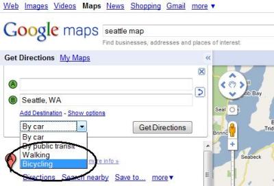
 The long wait is over for bicyclists who want to use Google maps to find the quickest, safest way from Point A to Point B.
Google maps launched a Beta version of its direction finder for bicycle routes on Wednesday. (See the “How-to” video below)
The biking directions release comes in conjuction with the opening day of the National Bike Summit in Washington DC.
Folks who use their bicycles for commuting and running errands have been advocating for Google to add a layer for bicycles to its “Get Directions” function for cars, public transit and walking.
A petition started by Peter Smith at Google Maps 'BikeThere' received more than 50,000 signatures from bicyclists who wanted the service.
Google had hinted that the project was underway back in October 2009 when it announced that it had added thousands of miles of bike paths to Google maps in cooperation with Rails to Trails Conservancy. At that time, the company said that “Directions are next.”
Public data
The bicycle route finder uses data gathered on bike paths, bike lanes and low-traffic streets to arrive at the suggested route. Google staffers are quick to alert that this project is in Beta, and they've built in ways that users can inject their feedback into the results at “report a problem.”
The results might not show the most direct route. Not only safety, but topography is factored into the route-finding formula.
The route-finding function calculates the energy that cyclists would have to use to reach their destination. The system is tuned to the less hard-core cyclists, which might irk some cyclists who don't mind tackling a few hills. (Read what Google says about the biking directions release.)
Those lines
When you go to Google maps and search by directions, simply choose “bicycling” in the drop down menu (it's under “by car”). The map that appears shows the suggested route as a blue line.
There are other lines on the map, that may help bicycle riders choose alternative routes:
— Dark green line: Bike trails
— Light green line: Streets with bike lanes
— Dotted green line: Other streets recommended for cyclists
Google displays turn-by-turn directions on the left, with links to “street views” of those intersections.
If applicable, it lists different options for routes, or you can click on the blue line to move the route along other designated bike trails, lanes and safe streets. You can go to “Report a Problem” for mistakes.
See the Google “Share Your Ride” Sweepstakes for $2,500 voucher at American Cyclery.
Test run
I gave the route-finder feature a couple of quick spins while writing this story and didn't see anything alarming in the results. In fact, it chose the exact route I had planned to ride from Bellevue over to Terminal 91 at Smith Cove in Seattle for this weekend's Seattle Bike Expo. See Google bike map.
Just for grins, I thought I'd test it out on a cross-country bicycle tour route from Yorktown, VA, to Astoria, OR. This was kind of a dirty trick, because the route doesn't pass through many big cities.
Instead of choosing Adventure Cycling Association's TransAmerica Trail, the Google maps route headed north to Washington DC then up to Pittsburgh via the C&O Canal Towpath and the Great Allegheny Passage. From there it continued heading northwest to the northern tier.
Interestingly, the Google route was 3,463 miles, compared to 4,262 miles for TransAmerica, and it bypassed some steep climbs I remembered in the Appalachian and Rocky Mountains. “TransAmerica” map via Google.
Google maps “How To” video
The project
The team of Google engineers who built the new feature are located in the Fremont neighborhood of Seattle, not far from the Burke-Gilman Trail, according to Brier Dudley's blog at the Seattle Times. Said Shannon Guymon, project manager:
“We are hoping by launching this feature we encourage more bike riding. Giving this data on the maps makes it seem more accessible.”
The group worked on the project for about five months, with help from other offices around the country.

Recent Comments