Many of the rails-to-trails routes in Washington state are suitable for skinny-tired road bikes. In fact, the majority of the 63 rails-to-trails in the state have surfaces that road bikes can handle.
Not the Klickitat Trail in southern Washington. One of the most remote rails-to-trails in the US, it is recommended that visitors use mountain bikes, preferably with front suspension.
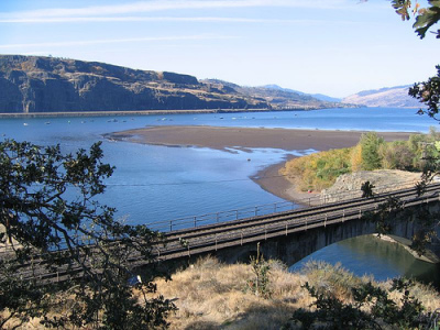
The 31-mile trail between Lyle and Warwick is the trail-of-the-month for the Rails-to-Trails Conservancy. The trail passes through Swale Canyon then hooks up with the meandering Klickitat River, nationally designated as a Wild and Scenic River. It ends at the confluence of the Klickitat and Columbia rivers (above).
Bicycling
The Klickitat Trail Conservancy has published some helpful tips on Mountain Biking the Klickitat Trail. Some groups enjoy setting up a shuttle for a one-way trip, while others ride a 51-mile loop that includes paved roads and the unpaved trail.
Unlike a ride along an urban bike path, there are fences and gates that cross the trail. Cyclists must open and close these gates to prevent cattle from escaping this open range area.
Also, the KTC warns cyclists to be on the lookout for fallen rocks, ticks, poison oak, rattlesnakes, and — worst of all — yellow star thistle burrs. Also, check ahead to determine if Swale Canyon has been closed due to fire danger (it reopened from the summer closure Oct. 3, 2007).
In spite of those trials, visitors will be rewarded with a range of high desert vistas and forested woodland.
Trail advocates
The trail had been a bone of contention between users and area landowners until some frequent trail walkers formed the Klickitat Trail Conservancy in 2002 and got support in the adjacent towns of Lyle and Klickitat.
The KTC also brought together the state parks department of Washington and the US Forest Service to develop the trail.
Essentially, the trail would not have come into being without the work of those local volunteers.
If you're planning to visit the Klickitat Trail, check out the conservancy website. It has maps and reports on the conditions of the trail, as well as related information for a visitors.


Recent Comments