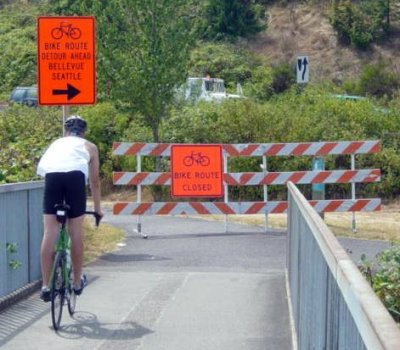
 These are the types of signs I hate to see when I'm out bicycling. How long is the detour? How many hills? How much gravel?
The Washington State Department of Transportation closed the bike trail beneath I-90 near Bellevue Way on Monday morning for about the next 10 days.
What it means for bike commuters between the Eastside and Seattle is that they'll have about an extra mile commute until the path is opened again.
The section of closed bike path is short — only from the base of the Mercer Slough bridge, above, to the hill near east of Enatai Beach. The detour, however, is about a mile long.
From the east, cyclists wind along the path (some gravel) that leads to the South Bellevue Park and Ride, cross Bellevue Way with the traffic light, then continue up the hill on 112th Avenue SE to SE 34th Street and the I-90 bridge over to Mercer Island.
The route is well-marked with bright orange signs.
A WSDOT press release says the reopening should occur no later than the evening of July 25.
The bike path has been closed to crews can repair a storm drain outfall and perform other drainage-related work for future transit and HOV operations projects.
Joy Bueling, communications director for the City of Mercer Island, says a copy of the WSDOT press release and a detour map is posted on the Mercer Island website.
“Since many Mercer Islanders and cyclists from all over the region use the I-90 path, we felt it was important to make this information as accessible as possible.”

Recent Comments