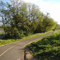
 An outdoor trip and adventure planning website has named the Top Trails for 2005. The list of 100 includes five bike routes, although the American River Bike Path (left) in California is mentioned twice — once for mountain bikes and once for road bikes.
The company, Trails.com, calls the list the closest thing to a Nielsen's rating system for trail popularity in the US. The staff compiled the list based on use of its proprietary trail data, including trail page visits, trail review submissions and trail guide views.
The Trails.com most popular trail was Breakneck Ridge Trail in New York (I didn't see a hike listed for Breakback Mountain).
 Among the bicycle routes, the 32-mile American River Bike Path, right, that runs from Sacramento to Folsom Lake was ranked twice on the list, once for mountain bikers at No. 14 and again at No. 83 for road bikes.
The paved trail leaves downtown Sacto on a gently rising slope to Folsom Lake in the Sierra Foothills. I've pedaled this before, and it makes for a great round trip from Old Town because the return trip is all downhill. The final leg of the path was completed in 1985. Trails.com notes it roughly follows a cinder track route laid by the Capital City Wheelman back in 1896.
The other three bike routes on the top trails list:
Ringwood State Park in northeastern New Jersey, No. 47 — The 5,000 acre park has many off-road cycling paths, including a singletrack racecourse maintained by a local club.
Nassau-Suffolk Greenbelt Trail in New York, No. 53 — An 8-mile one-way designated mountain bike path through a protected wilderness corridor on Long Island. The entire 22-mile greenbelt trail nearly spans the width of Long Island.
Aliso / Wood Canyons Regional Park: Rock-It / Cholla Loop, Laguna Beach, CA, No. 91 — A series of mountain bike trails criss-cross the 5,000 area tucked between Laguna Beach and Laguna Hills.
The Trails.com website, launched in 1999, partners with guidebook publishers to give access to more tha 30,000 guidebook trail descriptions. The membership website also features USGS topo maps, GPS tools, aerial photos, among other services.
See the Trails.com press release for the top 100 trails.

Recent Comments